Lakes, Rivers & Waterfalls in County Tipperary

Most of this list sits in the north of the county, along the Tipperary shore of Lough Derg. Dromineer has the harbour, a swimming beach and a yacht club founded in 1835, and the villages of Terryglass and Portroe are a short drive around the water from it. Above them, the Arra Hills give a 12.4 km loop over Tountinna, and the Lookout car park on the R494 at Portroe is a viewpoint for anyone not walking it.

The mountain water is on the southern and western rims. Bay Lough is a corrie lake in the Knockmealdowns, reached by a short downhill walk from the Vee road above Clogheen and at its best in late May when the rhododendron is out. Lough Curra sits at about 574m under Galtymore, an 8.5 km loop from Glengarra Woods that needs no scrambling, and the Comeraghs hold their own set of corrie lakes further east.

The rivers are the connecting thread. The Suir runs through Clonmel, the Nenagh River passes the five-arch Ballyartella Bridge of about 1720 on the Slí Eala riverwalk, and the Ballyfinboy and Little Brosna both drain north into the Shannon along the Offaly border. Winter suits the Little Brosna callows and their wildfowl; summer suits the lake harbours.

Where to start

  1. Clonmel – honey meadow on the River Suir Clonmel

    The county's biggest river town, set on the Suir, where Hugh Dubh O'Neill held out against Cromwell for three weeks in 1650.

  2. Lough Derg – Shannon lake and blueways Clare

    Ireland's third-largest lake, shared with Clare and Galway, with harbour villages, Holy Island's 6th-century monastery and 160 km of blueways to walk or cycle.

  3. Arra Hills – a loop above Lough Derg Nenagh

    A strenuous 12.4 km circuit above the lake shore between Nenagh and Ballina, though the car park it starts from is a viewpoint in itself.

15 of 15 shown — tap a pin for the place.

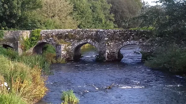
County Tipperary - Ballyartella Bridge - 20190828091218
County Tipperary - Ballyartella Bridge - 20190828091218 Dromineer paul / Wikimedia Commons / CC BY-SA 4.0

Ballyartella Bridge – a 1720 river crossing

Nenagh, tipperary

Ballyartella Bridge is a five-arch limestone crossing over the Nenagh River, built about 1720 and widened rather than demolished when the Road Act of 1727 raised the standard for road widths. It sits beside a ruined tower house, a working woollen mill and a weir, on the Slí Eala riverwalk five kilometres north-west of Nenagh.

🌳 Outdoor 🅿️ Free Parking 🐕 Dogs Welcome
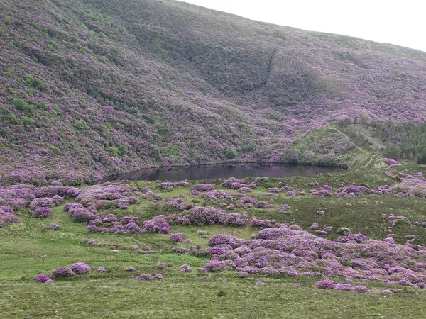
Bay Lough - geograph.org.uk - 4032472
Bay Lough - geograph.org.uk - 4032472 Hywel Williams / Wikimedia Commons / CC BY-SA 2.0

Bay Lough – a witch and a bottomless lake

Clogheen, tipperary

Bay Lough is a corrie lake scooped into the Knockmealdown Mountains above Clogheen, reached by a short downhill walk from the car park on the Vee road. It is free, tied to the legend of the witch Petticoat Loose, and at its best in late May when the rhododendron blooms; kayak hire runs on some summer weekends.

🌳 Outdoor 🅿️ Free Parking 🐕 Dogs Welcome
Aerial view, Dromineer Harbour, Co Tipperary
Aerial view, Dromineer Harbour, Co Tipperary Courtesy Failte Ireland

Dromineer – a Lough Derg harbour village

Dromineer, tipperary

Dromineer sits where the Nenagh River meets Lough Derg, its harbour overlooked by an ivy-clad medieval tower house. The Lough Derg Yacht Club here, founded in 1835, is reckoned among the oldest yacht clubs in the world, and a new €1.2 million water-sports hub with full wheelchair access is due to open in late 2026. Cafés, a swimming beach and e-bike hire round it out.

🌳 Outdoor
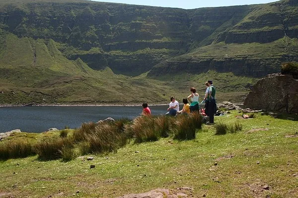
Lough Muskry - geograph.org.uk - 833518
Lough Muskry - geograph.org.uk - 833518 kevin higgins / Wikimedia Commons / CC BY-SA 2.0

Lough Muskry – swans, serpents and cliffs

Rossadrehid, tipperary

Lough Muskry fills a corrie at 493m in the Galtee Mountains, one of the range's five classic glacial lakes. The walk from Rossadrehid runs 8-9 km through forestry and open moorland to dark water hemmed by sandstone cliffs and the O'Loughnan's Castle outcrop. Folklore ties it to swan-maidens and a serpent St Patrick is said to have chained beneath the lake.

🌳 Outdoor

Questions people ask

Where in Tipperary are most of these places?
The largest group is in the north of the county on Lough Derg: Dromineer, Terryglass, Portroe, the Arra Hills, Ballyartella Bridge and the Ballyfinboy River are all within reach of Nenagh. The mountain lakes sit far to the south, above Clogheen and in the Galtees.
Which ones can I see without a serious hike?
Dromineer and Terryglass are harbour villages you can walk around. The Lookout on the R494 at Portroe is a roadside view over Lough Derg. Bay Lough is a short downhill walk from the Vee car park, and Ballyartella Bridge sits on the Slí Eala riverwalk.
Which are the proper mountain lakes, and how hard are they?
Lough Curra is the highest water in the Galtees at about 574m, an 8.5 km loop from Glengarra Woods graded moderate with no scrambling. The Arra Mountains Loop is 12.4 km and strenuous, around six hours. The Comeragh corrie lakes and Knockanaffrin ridge are exposed hill ground.
Can I get in the water anywhere?
Dromineer has a swimming beach and e-bike hire, with a wheelchair-accessible water-sports hub due in late 2026. The flooded slate quarry above Portroe draws scuba divers. Bay Lough has kayak hire on some summer weekends, and Lough Derg itself is the main boating water.
When is the best time of year to go?
Late May is the pick for Bay Lough, when the rhododendron is in bloom. Winter suits the Little Brosna callows, when flooded grassland fills with wildfowl. The Lough Derg villages and the blueways are at their busiest and most useful through summer.

← All things to do in County Tipperary

Book tours & tickets

Powered by GetYourGuide

We may earn a commission if you book through this link, at no extra cost to you.

Book tours, skip-the-line tickets and day trips with GetYourGuide. Free cancellation on most experiences.

See tours & tickets in County Tipperary →
Advertisement