
Overview
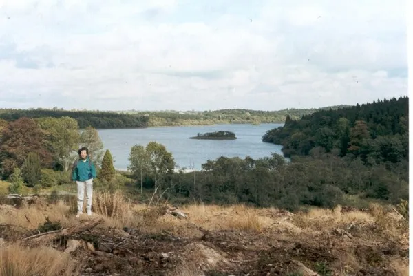
The reason to come to Dartrey is the Dawson Mausoleum: a roofless miniature of the Pantheon, set on a wooded island between two loughs. The forest lies near Rockcorry in County Monaghan, on the former demesne of the Dawson family, who later held the title Earl of Dartrey; Coillte now manages it as woodland. The landscape is a chain of loughs linked by the Dromore River, with a scatter of Georgian and Victorian stonework through the trees.
Before you set out, check Coillte’s notices and the Dartrey page. Forestry work or storm damage can affect a route, so follow any signs on the day, especially if you want the Temple Loop out to the mausoleum.
A Legacy of the Dawson Family
The area’s name traces back to the ancient Kingdom of Dartrey (or Dartraige), a sub-kingdom of the Airgíalla federation that once stretched across much of what is now Monaghan and Louth. By the early 18th century, the Dawson family had established Dawson Grove as their country seat. Thomas Dawson, later raised to the peerage, transformed the landscape into a grand estate, commissioning some of Britain’s finest young architects and sculptors. The house that crowned it, designed by the Scottish architect William Burn in the Jacobethan style, was completed in 1846.
The family’s fortunes waned in the 20th century. The contents of Dartrey House were sold in 1937, the land later passed into State forestry, and the mansion itself was demolished in the mid-20th century – sources differ between 1946 and 1950. Only the stables and fragments of the original farmyard remain today, quietly absorbed into the surrounding woodland.
Key Monuments & Historic Sites

The Dawson Mausoleum (Lady Anne Temple)
Black Island, a landmass separating the Inner and Outer Loughs, is the setting for the mausoleum. Designed by the young James Wyatt around 1770, the roofless structure is a miniature replica of the Pantheon in Rome. It was commissioned by Thomas Dawson to commemorate his first wife, Lady Anne Fermor, who died aged 36. At its centre is a marble group depicting a grieving father, their young son and an angel gathered around an urn.
The mausoleum holds no remains today, but the temple remains a poignant monument to loss. After decades of exposure and vandalism, the Dartrey Heritage Association and the Irish Georgian Society have worked on the restoration of the dome, brickwork and interior. You can look for it from the Temple Loop; stay on the path around the monument and follow the signs.
St John’s Church
Overlooking the Inner Lough and Black Island lies the Church of St John the Evangelist, often called Dartrey Church. Originally built in the late 1720s or early 1730s, this neo-Gothic stone church was extensively remodelled throughout the 19th century, gaining pointed arches, lancet windows and buttressed corners. Unlike many estate churches that fell into ruin, St John’s has remained a Church of Ireland parish church within the woodland.
The Dawson Monument & Famine Wall
Just outside the main forest gate along the R188 stands the Dawson Monument, a neo-Classical column erected around 1810. Also designed by James Wyatt, it serves as a roadside landmark marking the boundary of the former demesne. Approaching the estate from Cootehill, you will notice the Famine Wall, a low stone boundary that runs halfway along the road to Rockcorry. This quiet reminder of the Great Famine period underscores how the landscape witnessed both aristocratic ambition and the profound social upheavals of the 19th century.
Walking & Family Activities
Coillte lists three waymarked loops, which between them cater for most abilities:
- Fairfield Loop – about 2 km, easy, green markers.
- Deer Park Loop – about 5 km, moderate, blue markers.
- Temple Loop – about 7 km, moderate, red markers, with the Dawson Mausoleum visible from the route.
Follow the markers from the forest car park. The paths wind through mature planting and along the river and loughs, and the monuments give the routes a series of waypoints. The loughs and riverbanks are good for birdwatching. If forestry work or storm damage affects a route, follow the signs and check Coillte’s notices, as not every trail may be open on the day.
Practical Information
- Access & Parking: Use the signed Coillte forest car park and follow the markers from there. From Cootehill, the route follows the R188 past the Dawson Monument.
- Opening Hours: Check Coillte’s notices for any closures or route changes before travelling.
- Admission: Free entry.
- Facilities: Check the Coillte page for what is provided on site, and bring your own refreshments. The nearby village of Rockcorry has shops and other local amenities.
- Getting There: Dartrey Forest sits just south-east of Cootehill and is reached from the R188, with the village of Rockcorry close by.
- Tips: Wear sturdy footwear, as paths near the loughs can be uneven or damp after rain. Take care on any bridges and boardwalks. For the broader heritage of the area, the estate sits within easy reach of other Monaghan landmarks, including the Cassandra Hand Folk & Famine Centre and Rockcorry Village and Castle Ruins.