
Overview
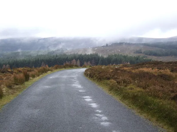
The British army built this road to catch one man. After the 1798 rebellion, rebels under Captain Michael Dwyer were using the Wicklow Mountains as cover, and there was no road running north to south across them. So the army cut one, from Rathfarnham on the southern edge of Dublin over open bog to Aghavannagh, with the stretch most visitors drive today running down to Laragh and Glendalough. It worked as a military project and, two centuries later, it is a scenic mountain drive and still a working public road.
If you only have an afternoon, drive it south towards Sally Gap, where the R115 crosses the R759, and carry on down past Glenmacnass to Laragh. That single run takes in the best of it, and it pairs naturally with Glendalough for a day out.
One honest caveat before you set off: this is a drive that lives or dies on the weather. On a clear day the views run for miles; in low cloud or heavy rain you are paying narrow, exposed roads for the privilege of seeing nothing. Check the forecast and current road notices, and if the tops are in fog, save it for another day.
History & Background
Construction began on 12 August 1800 and finished in October 1809, under engineer Alexander Taylor (b. 1746), who built much of the country’s early road network. Four barracks went up along the route to garrison it, at Glencree, Laragh, Glenmalure and Aghavannagh. Several survive as ruins; Glencree has been repurposed as the Glencree Centre for Peace and Reconciliation. With its barracks and largely unaltered line, it counts as a historical monument that still does duty as a working road, an unusual double life for a heritage site.
The section that now forms the R759 across the Sally Gap follows an older east–west track along the Cloghoge River. A higher, exposed alignment here earned the name ‘Murderin’ Pass’ for its treacherous winter conditions, and the name has stuck.
What to See & Do
Stop only where you can park clear of traffic, using designated parking or safe signed lay-bys, and keep junctions and passing places clear.
- Sally Gap – The crossroads at the high point, where the Military Road (R115) meets the R759. The view is blanket bog, granite and sky, and it feels nothing like the city half an hour north. The R759 offers an east–west route from here.
- Lough Tay – The ‘Guinness Lake’, so named because the dark water above a pale sand beach looks like a pint of plain. Lough Tay and its shore are private. For a managed view over the lake, use the marked route towards the J.B. Malone Memorial in Ballinastoe Woods. Coillte reports access restrictions during storm repairs, so check the Ballinastoe woods page and follow posted diversions.
- Glencree – The first major stop south of Dublin, with the former barracks and a quiet German war cemetery for sailors and airmen who died off the Irish coast in the World Wars. See Glencree and check access separately for each.
- Lower and Upper Lough Bray – Two small glacial lakes a short detour north of Glencree, set under heathery slopes.
- Lough Dan – Visible from the road. The lake and its shore are private, with no public access.
- Glenmacnass Waterfall – A cascade spilling down the rockface a few kilometres west of the pass. Keep well back from the waterfall and off the wet rocks above it; people have come to grief here.
- Glendalough – The road drops to Laragh, the gateway to the 6th-century monastic city with its round tower, ruined churches and two lakes, and marked walks. Allow time to visit away from the road itself.
- Powerscourt Estate – Not on the route, but a short hop from Enniskerry to the waterfall and the formal gardens, if you are building a fuller day.
Walking & hiking
The road is a handy launch point for hill walks:
- Djouce Mountain – From the JB Malone car park, a climb to the 724 m summit with a ridge walk and long views across the range.
- Djouce and White Hill – A ridge walk on the Wicklow Way.
- Lough Ouler – A boggy walk to a remote corrie lake for experienced hillwalkers. Plan the route with a map, use only lawful parking and wear sturdy boots, not trainers.
- Ballinastoe Woods – A gentler woodland walk near the northern end. Check the Coillte Ballinastoe page for current access restrictions first.
Cycling
The Sally Gap loop on the Military Road and R759 is a serious ride, with steep gradients, exposed wind and blind bends, and ice a real risk in winter. Helmet, high-vis and a weather check before you go.
Food & refreshments
There is nothing on the mountain section itself, so plan ahead. Laragh at the southern end and Roundwood off the eastern side of the loop have places to eat. Pack waterproofs and something to eat, and don’t rely on your phone, as coverage can drop out across the bog.
Practical Information
- Road condition: Paved but narrow, with oncoming traffic, blind bends and the odd sheep on the tarmac. Turn back if snow, ice or poor visibility make the route unsuitable.
- Winter travel: Snow and ice can close the pass. Check Met Éireann, current road notices and local signs before travelling.
- Parking: Use designated parking or safe signed lay-bys, and keep junctions and passing places clear. There are no formal car parks along the mountain section itself.
- Getting there: A car is the practical option; no public transport serves the Sally Gap itself.
- Facilities: Do not expect any on the pass. Plan toilets and food for Glendalough, Roundwood or Laragh, and check what is open before you rely on it.
- Local information: Wicklow County Council for road notices.
Tip: Morning light is best, as the road faces the rising sun and the bog colours come alive early. Come after a few days of rain and Glenmacnass goes from a trickle to a roar; come in a dry spell and it is a modest step.