
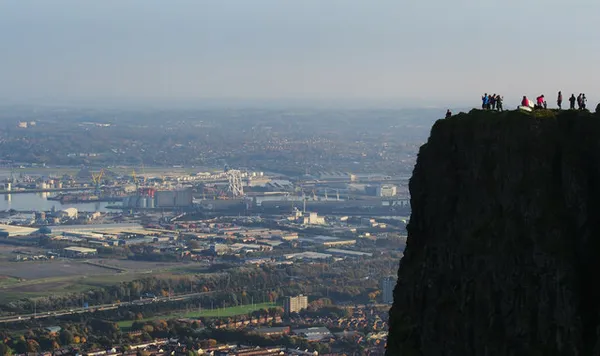
McArt’s Fort is the flat top of a rocky spur of Cave Hill, the basalt scarp that rises 368m (1,207ft) straight up behind Belfast and shows the city the profile it calls ‘Napoleon’s Nose’ (the hill’s older name is Ben Madigan). From the fort the city lies out below you, the River Lagan threading through it to Belfast Lough and the shipyard cranes, with the hills of County Down across the water on a clear day. That’s the reason to make the climb, as the earthworks themselves are subtle.
Is the route to McArt’s Fort open?
Belfast City Council’s Cave Hill notice lists the route between the Devil’s Punchbowl and the fort as closed because of erosion. The council’s signed route to the fort goes through the limestone quarry. Follow that signed route, check the notices before you start, and do not use informal paths or park informally on nearby roads.
The fort
It’s an Iron-Age rath, so the better part of two thousand years old. The flat top runs about 46m north to south by 55m east to west (150ft by 180ft), defended on one side by the sheer cliff, the ‘nose’ itself, and around the rest by a single ditch roughly 3m deep and 7.6m wide, still clear on the ground. The O’Neills of Clandeboy were inaugurated here, and a rough stone chair known as the Giant’s Chair, thought to be their inauguration stone, stood at the fort until it was smashed by vandals in 1896. The name most likely comes from an O’Neill, either MacArt O’Neill, said to have died in the Elizabethan wars, or Brian McArt O’Neill of the Nine Years’ War; the derivation was never quite settled.
Rebellion on the hill
Cave Hill’s real fame is political. In 1795 Theobald Wolfe Tone, Henry Joy McCracken and other United Irishmen are said to have climbed to the summit and sworn to break the connection with England, the compact that fed into the 1798 rebellion. Three years later, with the rising collapsed, McCracken was captured on the hill before he could escape. The five caves that give the hill its name are cut into the basalt below the fort. They are likely early iron mines rather than natural, and they added to the hill’s long use as a refuge.
The walk
The walk to the fort is uphill on uneven ground and is not suitable for wheelchairs or buggies. Follow the council’s signed route through the quarry and check the park’s gate times before you set off. Longer, more scenic routes start lower down at Belfast Castle or the zoo and climb through woodland; note that Belfast Castle is a destination in its own right at the foot of the hill, not a quick detour off the summit path. Check the council notice for which of these routes are currently open. Whichever way you come, a few things on the tops are worth knowing about:
- The Devil’s Punchbowl – a deep, natural amphitheatre gouged by ice, once used to corral cattle, with its own drop of a view over the city. The route from here to the fort is currently closed, so look for the council’s signed alternative.
- Napoleon’s Nose – the profile reads best when it’s backlit; seen from the city near sunrise or in the late afternoon you get the shadowed outline.
- The grassland – the summit is species-rich grassland; ravens, buzzards and kestrels ride the updraughts off the cliff.
Practical information
Getting there – follow the signs for Cave Hill Country Park and use the council’s signed route to the fort. Check the council’s Cave Hill page for current entrances and parking.
Opening and admission – the park keeps gate times that change through the year, so check them on the council page before you set off. There is no charge to visit the fort.
Safety – the ground can be steep and exposed, and the wind gets up fast, even in summer. Stay well back from cliff edges. Wear boots with grip, as the ground is slick when wet, check the forecast, and take extra care in winter for ice and short daylight.