
Overview
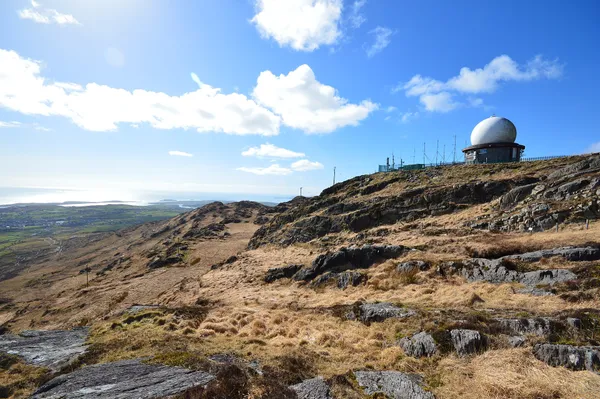
Mount Gabriel (Irish: Cnoc Osta) stands 407 m above Schull on the Mizen Peninsula. On a clear day the view takes in Schull Harbour, Long Island Bay and the scattered islands of Roaringwater Bay, with the Beara Peninsula, south Kerry and Fastnet Rock out to sea.
The radar domes
You will spot the summit long before you reach it: two white radar domes, known locally as ‘Gabriel’s Balls’. They went up in the late 1970s as part of the Eurocontrol air-traffic-control network. In September 1982 the Irish National Liberation Army bombed the domes, wrongly believing they served NATO; they were rebuilt. The domes are an aviation installation, and a route to the radar installations should not be treated as an approach to the mines.
Bronze Age copper mines
The reason this hill matters is older by three and a half thousand years. On the eastern slope, shallow workings and piles of spoil are what remain of an early copper-mining complex. The OPW records 31 confirmed mines, dated to around 1700–1500 BC. The site is a state-owned National Monument.
The technique was fire and water. Miners burned wood against the rock face, doused it to crack the stone, then broke it up with stone hammers. Excavations recovered the fire-setting hearths and the short-handled alder shovels and picks they used.
Be honest with yourself about expectations: these are shallow hollows in the hillside, not a show-cave.
The Cauldron Pool
Near the summit is a small spring-fed pool, marked on old Ordnance Survey maps as Poll an Oighin, the Cauldron Pool, and wrapped in folklore collected in the Dúchas Schools Collection. One story has the Archangel Gabriel leaving his footprint here; another credits Fionn Mac Cumhaill with hurling the rock that became Fastnet and leaving this hollow behind. A third, taken down in the 1930s, tells of a chieftain’s daughter who fled to the mountain and was nearly claimed by the ‘Good People’ of the well, the water rising and then running underground to Schull Harbour.
Access and practical tips
The mining complex is an unguided national monument. Confirm local access before travelling, respect gates and signs, and keep out of the old workings. Check the Heritage Ireland page for current information on the site. The summit is exposed, so wind and temperature can change fast, and you should dress for the weather. Under the Wildlife Acts, burning vegetation is banned from 1 March to 31 August.
Nearby
Schull sits just below, with pubs, cafés and summer boat trips. Mizen Head is a short drive west. For more mining history, and a visit with a museum, the Allihies Copper Mines on the Beara Peninsula make an interesting 19th-century comparison.