
Overview
Raphoe is a small heritage town in the Laggan, the fertile stretch of east Donegal that has been farmed since the Neolithic. It’s one of the county’s designated heritage towns, and its Irish name, Ráth Bhoth (‘ringfort of the huts’), points back past the plantation to early monastic life. The town today is arranged around the Diamond, a rectangular market square laid out on the strict grid of the 17th-century Ulster Plantation and lined with Georgian frontages, churches and civic buildings.
Start at the Diamond and look for the tower of St Eunan’s Cathedral. The cathedral is a working church, so check access before you plan to see the interior. The bishop’s palace is a separate ruin. Follow local signs and stay outside restricted areas. Beltany stone circle, on a hill outside the town, is a separate visit with its own approach.
Beltany Stone Circle
Beltany Stone Circle sits on a hill outside the town, a Bronze Age monument broadly dated between 2100 and 700 BC. Sixty-four stones survive in a ring roughly 45 m across; several carry cup-marks, and the setting has led archaeologists to argue for solar alignment and solstice-fire use, though how the ring worked is still debated rather than settled. It’s a National Monument, and the Heritage Ireland listing describes it as an unguided site.
Follow the signed approach, keep to permitted routes and respect gates and livestock. The ground can be wet or uneven, so wear shoes with grip and allow daylight for the return. Don’t expect staff or facilities on the hill. The Go Visit Donegal page has more on the circle.
A layered history
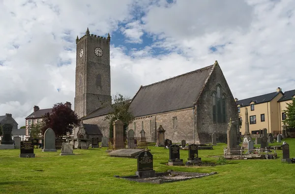
The town’s Christian roots go back to around 550 AD, when a Columban monastery was founded on the site of the present cathedral. St Eunan’s Church of Ireland cathedral still stands on the Diamond: the building is largely of the 1730s, but 12th-century fragments are built into its walls, and it’s dedicated to Saint Eunan (Adamnán), the abbot of Iona.
By the 1630s the medieval bishop’s palace had been fortified into Raphoe Castle. It had a hard century and a half – besieged in the 1641 rebellion, taken by Cromwell’s forces in 1650, damaged in 1689, attacked by the United Irishmen in 1798 – before an accidental fire in 1838 reduced it to the roofless shell that still frames the western edge of the town. It is a ruin rather than a visitor attraction, so look at it from outside and keep clear of any restricted areas.
The plantation itself gave Raphoe its shape. Planners imposed the geometric grid on the Diamond, the same instinct that laid out Derry, and the era brought the Royal and Prior School (1737) and the bishop’s palace of 1636–37, fixing the town as an administrative and religious centre.
Walking the Diamond
The square works as a walking timeline, each building a different chapter. Check local arrangements before planning to see several historic buildings in a single visit, as interiors keep their own access.
- St Eunan’s Church of Ireland Cathedral – on the Diamond, 1730s work over 12th-century foundations. It is a working church, so check access before visiting the interior.
- St Eunan’s Catholic Church – built in 1874, a limestone building in Hiberno-Romanesque style with a distinctive round tower.
- The Royal and Prior School – on the west side, a working secondary school that keeps its 1737 Georgian boarding house.
- Masonic Hall – built in 1900 on the site of an old forge, carrying the Latin tag Audi, Vidi, Taci (‘hear, see, keep silent’) over the door.
- First Presbyterian Church – an 1876 neo-classical front on the south side, marking the Presbyterian community that settled here after the plantation.
- Volt House – a granite three-storey house east of the centre, built in 1732 for clergymen’s widows; the odd name has more than one local explanation and none of them proven.
The Deele River curves along the southern edge of the town, with quiet walking paths along its banks.
Nearby: Oakfield Park
Just outside Raphoe, Oakfield Park is a privately owned demesne with gardens, a hedge maze, sculptures and – the reason children remember it – a miniature-gauge railway you can ride through the grounds. Unlike the town’s open sites it has its own opening days and charges admission, so check its own website for current details before you drive out.
Getting there
Raphoe lies between Letterkenny and Derry/Londonderry, on the N13/N14. There’s no rail station in the town; the nearest is Derry/Londonderry. Bus links to Raphoe can be thin outside peak hours, so check current timetables before you travel without a car.
Practical information
Use designated parking in the town and at the signed Beltany approach. The Diamond is the natural place to start, and the cathedral, castle ruin and school can all be seen from the square. Interiors and Oakfield Park keep their own times. For more on the town’s buildings, Donegal County Council publishes a heritage brochure online.