
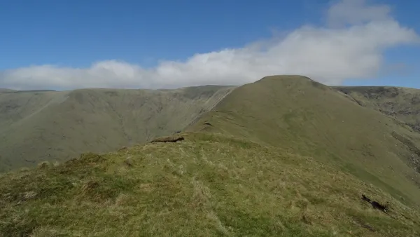
Overview
Barrclashcame, the high point of the Sheeffry Hills at 772 m, sits at the western end of a range of broad ridges inland of the Mayo coast. The high ridges are open mountain ground, with steep slopes and poor visibility in cloud. Locals say the name ‘Shay-free’; the Irish, Cnoic Shíofra, is usually read as ‘hills of the wraith’, a nod to the low mist that hangs on the tops.
If you want a walk rather than a mountain day, start at Coillte’s Tawnyard trailhead for the Western Way. Coillte lists Tawnyard Forest as a trailhead for the Western Way. The trail through the forest is part of a long-distance route, so pick a section and plan your return. Check the trail’s current notices before setting out.
Name and history
The hills are bounded by Glencullin Lough and Doo Lough to the west, Glenummera and Tawnyard Lough to the south, Owenmore Glen to the east and the Bunowen River to the north, wrapping a landscape of deep glens, quiet lakes and scattered townlands, among them Drummin, Carrowkennedy, Cregganbaun and Delphi.
The area carries the weight of the War of Independence. Carrowkennedy, on the eastern side of the hills, was the site of an ambush in June 1921, when an IRA column commanded by Michael Kilroy overran a police patrol; a modest memorial marks the spot.
The Sheeffry Pass
The pass is a single narrow mountain road threading through the heart of the range, and it is a way to see the hills if you are not a hillwalker. The view down over Tawnyard Lough is the reward. The road is unfenced and single-track and used by sheep, so take the bends slowly and slow down for livestock. Do not stop where you would block the road or a gateway. For the Western Way, use Coillte’s Tawnyard car park rather than roadside stopping.
Walking the ridge
The full east–west traverse is a long, serious hill day, unwaymarked for much of its length and reliant on clear tracks across the plateau. It takes in the main summits before Barrclashcame at the western end, and the views reach out to Achill and Corraun, the Nephin Begs, Mweelrea and Croagh Patrick. This is ground for experienced walkers with a map, compass and mountain forecast, not a casual afternoon: cloud can drop onto the plateau without much warning, and the western corries end in scree-strewn cliffs best left alone. If you plan to go onto an unmarked ridge, confirm access for your approach first, as summit access and route status are not confirmed here.
For something gentler, walk a section of the Western Way through Tawnyard Forest, starting from Coillte’s Tawnyard car park. Check the trail notices before you go.
Peaks and lakes
From west to east the plateau strings together Barrclashcame (772 m), Storikeennageer (580 m), Tievummera (762 m), Tievnabinnia (742 m), Tawnyard (436 m) and Tawnyrower (510 m).
The range holds a run of glacial lakes, including Lugacolliwee and Lugaloughan, with smaller corrie pools, Lough Brawn among them, scattered across the plateau and holding the light in still weather.
Nearby
South of the pass, the Doolough Famine Memorial, a stone cross on the road through the Doolough Valley, marks the deaths of people who walked this route between Louisburgh and Delphi in the winter of 1849. It is a short stop on a drive, and a sobering one. See also Louisburgh and Doolough.
Practical information
Getting there – The hills lie inland between Westport and Louisburgh. Access is off the R335 (Leenane–Westport) and the signposted road for the Sheeffry Pass. For the Western Way, use Coillte’s Tawnyard car park.
Maps – Carry a proper hill map and a compass or GPS: the plateau is unwaymarked in places and the tracks fade in mist. The relevant Ordnance Survey Ireland Discovery sheet covers the range.
Facilities – Do not count on any on the hills. The nearest cafés, pubs and shops are in Louisburgh and Westport, so fuel up before you head in.
Dogs – Check any rules on the Western Way and Coillte land, and keep dogs on a lead near sheep and on the boggy, exposed sections.
Accessibility – The terrain is rugged and steep; the walking routes are not suitable for wheelchairs or limited mobility.
Start any ridge walk early, check the mountain forecast, and pack an extra layer, because the plateau can be much colder and more exposed than the valley.