
Overview
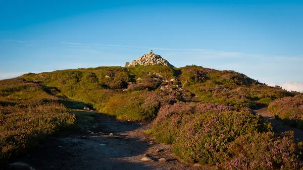
Two Rock Mountain (Irish: Binn Dá Charraig) rises to 536 m (1,759 ft) in the Dublin Mountains. Its name comes from the two granite tors on the south-eastern slope. A cairn known as Fairy Castle stands on the summit, and in clear weather the open ground gives views from Tallaght and Howth in the north to Bray Head, Killiney Hill, the Great Sugar Loaf and the Wicklow Mountains in the south. The hill is a working landscape of red-grouse heathland, shallow bog and native woodland, managed by Coillte and the Dublin Mountains Partnership, who are gradually converting the old commercial spruce plantations into native recreational woodland.
History & Ancient Monuments
The summit cairn is a sub-circular mound of granite and quartz blocks, roughly 27 m across and 3 m high. It crowns a Neolithic passage tomb that has never been excavated. Locally called Fairy Castle, it is part of a chain of summit tombs stretching across the Dublin and Wicklow ranges. On a clear day you can trace sightlines to the passage tombs on Montpelier Hill, Tallaght Hill, Saggart Hill and Seahan Mountain. Leave the cairn stones where they are; this is a protected monument.
Older maps refer to the hill as Black Mountain, while scholars propose the earlier Irish name Sliab Lecga (“Mountain of the Flagstones”). This name appears in the early-medieval Metrical Dindshenchas and the saga Togail Bruidne Dá Derga, where Mount Lecga serves as a waypoint for raiders.
On the south-eastern slope lies the Ballyedmonduff wedge tomb, often called the “Giant’s Grave”. Dating to the Bronze Age, it features a three-chamber gallery, a horseshoe arrangement of standing stones and a capstone bearing seven cup-marks. First opened in 1832 and re-excavated in 1945, it was reconstructed to its current form. Antiquarian John O’Donovan once called it “the finest pagan grave in any county”. Other lost monuments include the Greyhound’s Bed, a long cairn destroyed in the 19th century, and a triangular standing stone near the summit.
The mountain also played a part in one of the more dramatic episodes of Irish history. In 1591, Red Hugh O’Donnell escaped Dublin Castle and crossed Two Rock on his way to the O’Toole stronghold at Powerscourt. Recaptured, he made a second, successful escape in January 1592, reaching Fiach McHugh O’Byrne in Glenmalure, losing toes to frostbite on the way. That journey through these hills helped forge the alliance that shaped the Nine Years’ War.
Geology & Landscape
The two granite tors that give the mountain its modern name formed through the long weathering of muscovite-microcline porphyritic granite, which fractured along vertical and horizontal joints to leave the outcrops you see today. The summit plateau shifts from wet heath to blanket bog, while the lower slopes carry a patchwork of ferns, gorse and planted Sitka spruce and pine.
Flora, Fauna & Conservation
The open heathland is important habitat for red grouse, a species protected under Irish law. They nest on the ground in spring, and walkers are asked to keep to marked paths to avoid disturbing nests. Skylarks and meadow pipits are common in summer, while the bogs shelter invertebrates and wildflowers including heather, bilberry and crowberry. Coillte carries out regular heathland management to hold back scrub and keep the slopes open, and the Dublin Mountains Partnership runs community hikes and guided walks from time to time.
Walking & Trails
Use the marked walking trails from Ticknock Forest and check the Dublin Mountains Partnership map before choosing a route. Paths can be steep, stony and exposed above the forest, and the ground is uneven, so wear sturdy footwear. Check the Ticknock page for current trail and car park notices before setting out.
- Walk up from Ticknock – the signed routes climb through the forest to the open hill, and the cairn on the summit is the natural turning point. The lower sections are easier going than the exposed ground above.
- Two Rock and Three Rock – the Dublin Mountains Way links the neighbouring summits, giving ridge-top views, but check the map for the current route and distances.
- Wicklow Way – for anyone extending a trip deeper into the Wicklow Mountains, check the long-distance route maps rather than improvising a link.
Mountain biking is popular on the forest trails. Give cyclists room at shared crossings, and check the Dublin Mountains Partnership website before heading out, as sections are occasionally closed for repairs.
Cultural & Audio Experiences
The area has been the focus of arts commissions under the dlr Arts Nature and Place series. The Ticknock: What’s Going On? podcast by artists Listen and Breathe follows the forest’s changing landscape over millennia, and Méadhbh O’Connor’s Sky Walkers project adds poems set to ambient soundscapes, made to be heard while resting on the hill. Check the dlr Arts pages for what is currently available.
Practical Information
Getting there – From Dublin city centre, head south via Marlay Park and follow signs to Ticknock Forest. For buses, use the TFI journey planner for current services, as routes and weekend timetables change. For car-free options, see Hikes Near Dublin Without a Car.
Parking & Access – Use the signed Ticknock Forest car park and check gate times with Coillte. Parking arrangements, charges and capacity can change, and the car park is busy at weekends, so allow extra time or choose another time to visit. Do not park on the approach roads or block entrances.
Amenities – Check the Ticknock page for facilities before you go. Follow Leave No Trace: take all litter and dog waste home.
Accessibility – The trails are not wheelchair-accessible. The route to the summit involves steep, uneven ground, so sturdy walking shoes are essential, and you should not assume a buggy will get far.
Dogs – Dogs are welcome in the area, but keep them under close control, on a lead near grazing sheep and ground-nesting birds.
Seasonal notes – The hill is open year-round. Winter brings strong winds on the exposed summit and ice on the tors, and early autumn brings peak heather colour.
Nearby Attractions
- Ticknock Forest – A network of managed woodlands with more walking and cycling routes.
- Three Rock Mountain – A neighbouring peak with its own granite tors and communication masts.
- Kilmashogue – Home to further prehistoric sites, including a wedge tomb and a historic cemetery.
- Powerscourt Estate – On the historic Red Hugh O’Donnell route, with formal gardens, a waterfall and woodland walks.
For the best of the view, time your walk for late afternoon and stay for dusk, when the city lights come on across Dublin Bay. Carry a head torch for the walk down, and be careful on any boardwalk or stony sections.