
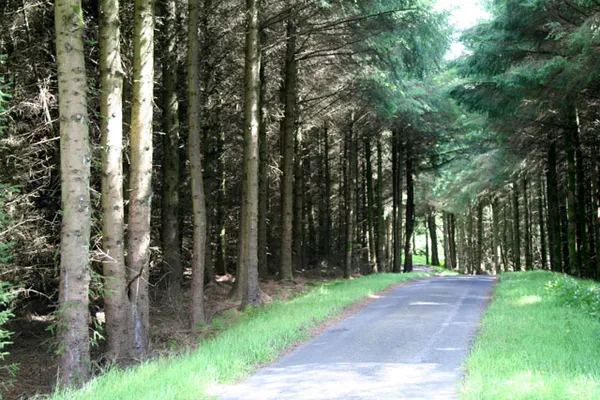
Overview
Ballypatrick Forest is an extensive upland forest on the Causeway Coast, between Ballycastle and Cushendall in County Antrim. Use the signed visitor car park off the A2 and follow the marked walking trail. The forest also has the stone-arched Irish Ford and open ground that looks out towards Rathlin Island. Entry is free.
It is a working forest, so check the nidirect page for current restrictions before you set out. Forest roads may not be open to cars, so plan this as a walk and follow the signs on the day.
History and heritage
The land’s connection to timber goes back to the 17th and 18th centuries, when the Stuart family cut native oak and larch for Royal Navy shipbuilding. Later the ground was used for hunting, lead mining and, during the Second World War, military training. The oldest surviving planted block dates to 1948 and stands at the entrance, its filtered light falling on the upland sheep pastures around the headwaters of the Carey River.
The forest is also known for its Double-Horned Cairn, a Neolithic burial mound built somewhere between 4000 and 2000 BC, between four and six thousand years ago. Instead of the usual single chamber it holds two, which makes it a rare type of megalithic tomb in Northern Ireland. Treat it as part of the area’s heritage rather than a destination to reach on your own: use only the waymarked paths and signed routes, and do not cross fields or fences to find it.
The other thing to look for is the Irish Ford, a stone-arched crossing where the forest road and the Corratavey Burn run together. It makes an easy photo stop.
Wildlife and nature
Ballypatrick is a working forest, so its cover shifts between commercial conifers such as Norway spruce and Scots pine, and native broadleaf stands of oak, birch, rowan and holly. Higher up there is open grassland and a stand of eucalyptus, planted decades ago and now naturalised.
Woodland and watercourses like these suit a range of wildlife, and spring brings bluebells and wild garlic. Give any animals you do see plenty of distance. Keep dogs under close control, and on a lead near grazing sheep.
What to see and do
- Marked walking trail – Follow the waymarks from the signed car park and stay on the marked route. Surfaces on forest roads can change, so use the waymarked walk and follow signs.
- Upland views – From the higher ground, on a clear day, you can trace the coastline towards Fair Head, pick out Rathlin Island and look south to Knocklayd.
- Long-distance walking – The Moyle Way and the Ulster Way both pass the western edge of the forest.
- Picnic spot – The Irish Ford and the burn make a pleasant place to stop.
Practical information
- Admission and parking – Free entry. Use the signed visitor car park off the A2.
- Restrictions – Sections can close for harvesting or forestry machinery. Check current restrictions on the nidirect page and read the on-site signs before heading off the main paths.
- Accessibility – The main trail suits families and moderate fitness. Steeper, root-strewn upper routes are not suitable for wheelchairs or mobility scooters.
- Dogs – Keep dogs under close control, especially near grazing sheep and the burn.
- Safety – Timber lorries and other forestry traffic use the internal roads. Leave them plenty of space, stay on the marked paths, and wear high-visibility clothing in poor light.
Tips for visitors
- Pack a waterproof and sturdy shoes. The ground near the watercourses stays damp and the higher trails turn muddy after rain.
- Mobile signal can drop in the denser conifer blocks, so check your route before you set off.
- Early morning or late afternoon is usually the quietest time to be in the forest.
If you do one thing here, walk in to the Irish Ford and stand under the arch. From there you are well placed to explore the wider Antrim Coast and Glens, including Kinbane Castle.