Benone Strand, a seven-mile expanse of golden sand along Northern Ireland's Causeway Coast, is a standout natural wonder distinguished by its clean, firm shores and uninterrupted vistas. A recipient of the European Blue Flag Award multiple times, most recently in 2024, it offers a pristine beach experience framed by the rugged cliffs of Binevenagh and sweeping views across Lough Foyle to Donegal's Inishowen Peninsula. The strand's unspoiled dunes and open landscape make it a haven for botanists and entomologists, with rare orchids and migratory butterflies thriving in its protected ecosystems. As part of both the Binevenagh Area of Outstanding Natural Beauty and the Magilligan Special Area of Conservation, the beach underscores its ecological significance while inviting exploration on foot or by watersport.
Historically and culturally, Benone Strand is layered with stories. In 2017, it pioneered accessibility in Northern Ireland as the region's first fully inclusive beach, partnering with the Mae Murray Foundation to provide mobility aids and specialist equipment for visitors with limited mobility. Nearby landmarks like Mussenden Temple-a cliffside folly perched dramatically above the sea-and the 19th-century Martello Tower, built to guard against Napoleonic threats, anchor the area in heritage. The strand also hosts echoes of scientific history: an Ordnance Survey baseline measured here in 1824 laid groundwork for mapping the British Isles, its accuracy still celebrated nearly two centuries later.
Visitors encounter a dynamic mix of tranquility and activity. The beach's soft, rock-free sand suits sunbathing and family picnics, while its consistent waves draw surfers, kiteboarders, and jet skiers to designated zones. Seasonal lifeguards patrol from July to August, ensuring safety during peak swimming periods. Beyond the shore, the Benone Tourist Complex offers amenities like tennis courts, splash pools, and a 9-hole golf course, though the true draw lies in the wild landscapes. The Umbra Dune Grasslands, a protected nature reserve, reveal a shifting mosaic of dune systems and hazel copses teeming with skylarks, adderstongue ferns, and rare moonwort plants.
The best time to visit hinges on personal preference. Summer months (May to September) offer warm waters and lifeguard supervision, ideal for watersports and sunbathing, though the dog-free zones during July and August require planning for canine companions. Autumn and winter bring solitude and dramatic skies, with the chance to spot porpoises offshore or even the Northern Lights on clear nights. Year-round, the strand's vastness ensures space for reflection, whether walking toward Magilligan Point-where a ferry connects to Donegal-or tracing the coastal pathways that lead eastward toward Mussenden Temple's iconic silhouette. Benone Strand's enduring appeal lies in its ability to balance adventure, conservation, and quiet contemplation, making it a cornerstone of the Causeway Coast's natural legacy.
Getting There
Nearest Airports, Train, and Bus Stations
The closest airports are Belfast International Airport (35 miles/56 km) and George Best Belfast City Airport (40 miles/64 km). For those flying into western Ireland, City of Derry Airport (15 miles/24 km) is the nearest regional option.
Train services to Coleraine station (the nearest major stop) connect to Belfast and other parts of Northern Ireland. Bus services to Coleraine also run from Belfast, Derry~Londonderry (City of Derry), and Portrush.
Driving Directions from Major Cities
- From Belfast: Take the M2 motorway toward Coleraine, then follow the A26/A2 toward the Causeway Coastal Route. The drive takes 1 hour 15-30 minutes.
- From Derry~Londonderry: Head south on the A6 and follow signs for Limavady. Continue onto the Seacoast Road (A2), a 40-minute drive.
- From Portrush: Follow the A2 east toward Coleraine; the beach is 30 minutes away.
- From Limavady: Drive north on the Seacoast Road (A2) for 12 miles (19 km).
Public Transportation Options
- Train to Coleraine: Rail services from Belfast or Derry~Londonderry terminate at Coleraine station.
- Bus 124: From Coleraine, catch the Ulsterbus 124 service, which stops at the Benone Beach entrance.
- Translink Journey Planner: Use Translink's online tool (journeyplanner.translink.co.uk) for real-time schedules and route planning.
Local Transport and Walks
- Bus 124 is the primary public transport option from Coleraine.
- Walking trails include routes from Castlerock (4 miles/6.4 km west) or Bellarena. Note that tidal conditions may affect paths near Mussenden Temple. A longer 13-mile (21 km) walk from Downhill to Magilligan Point takes around 4 hours.
Ferry Services
A car ferry operates from Magilligan Point (near the beach's western end) to Greencastle in County Donegal, Ireland. The 15-30 minute crossing connects the Causeway Coastal Route to the Wild Atlantic Way, offering a scenic alternative to driving through Derry~Londonderry.
Important Notes
Access to Magilligan Point may occasionally be restricted due to military firing range activity. Check local signage or contact authorities before visiting this area.
Parking
Parking is available at the entrance to the beach. The primary car park is located just behind the beach entrance, near the Benone Tourist Complex, and provides easy access to the sand. This parking area is free of charge, though visitors should note that occasional provider-specific charges may apply-check signage or use the JustPark app for real-time payment requirements. A limited number of disabled parking spaces are also provided in this area for accessibility.
In addition to the designated car park, on-beach parking is permitted in certain zones. However, visitors should exercise caution: park only on compacted sand to avoid sinking into soft or loose areas, and always monitor tide times to avoid being cut off by rising water. Seasonal restrictions or temporary closures may also affect beach parking, so it's wise to confirm conditions beforehand.
During peak seasons, the main car park may fill quickly, so on-beach parking serves as a practical alternative. The distance from the car park to the beach is minimal-just a short walk of about 50 meters. If driving on the beach itself, ensure you park legally and responsibly, adhering to any posted guidelines.
For parking pricing check the JustPark app or on-site instructions is recommended. Always prioritize safety by checking tide schedules and sand conditions before parking on the beach, and consider the beach as a backup option when the main lot is busy.
Nearby Attractions
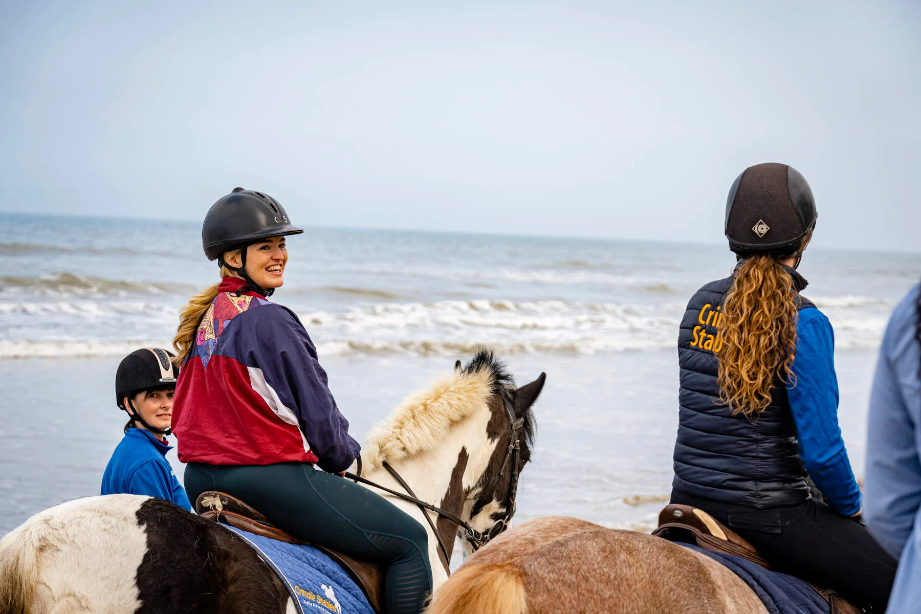
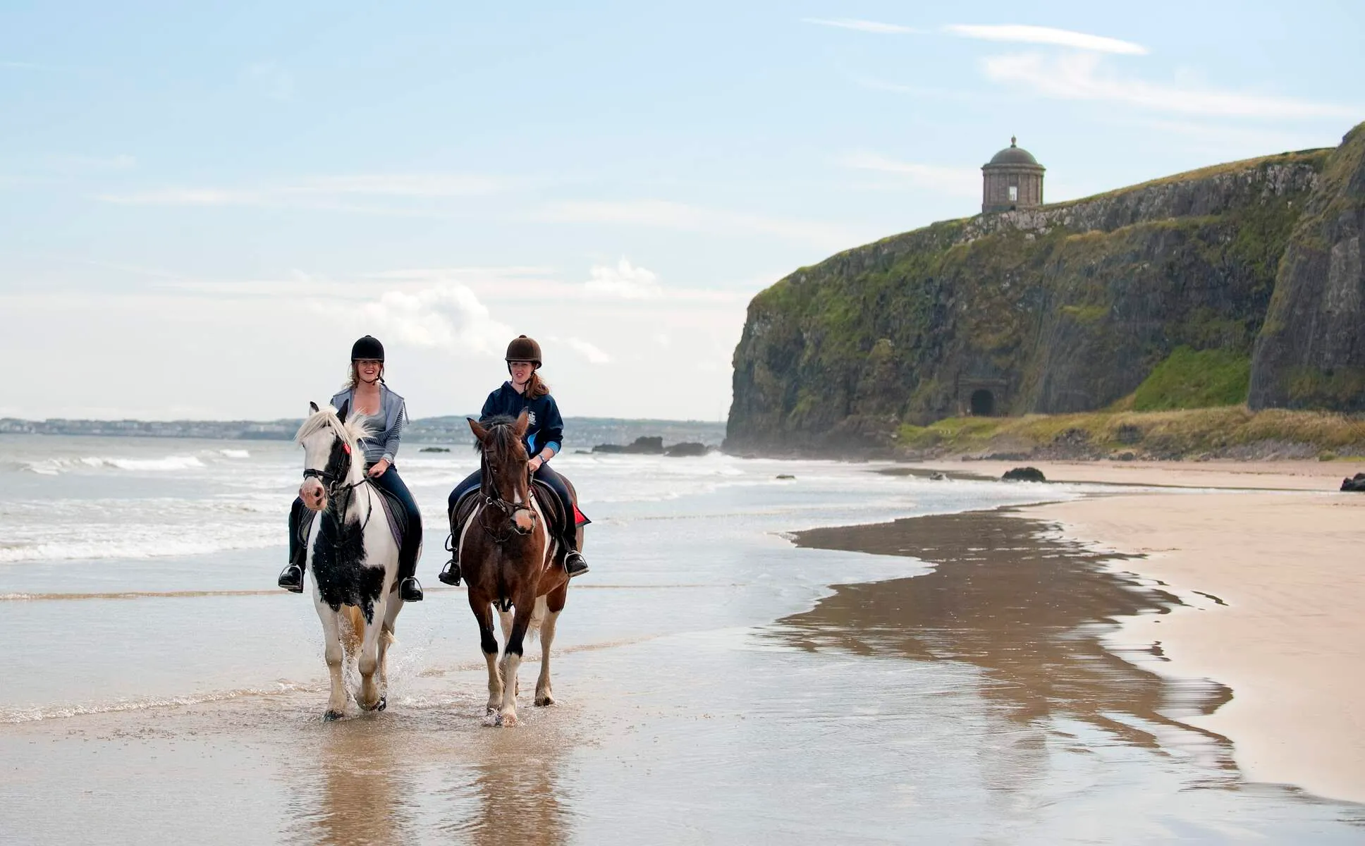
Crindle Stables
Set against the stunning backdrop of Northern Ireland's Causeway Coastal Route, Crindle Stables is a welcoming, family-run horse riding centre based on a working farm. Located near Limavady, its posit...
Distance: 11.9 km
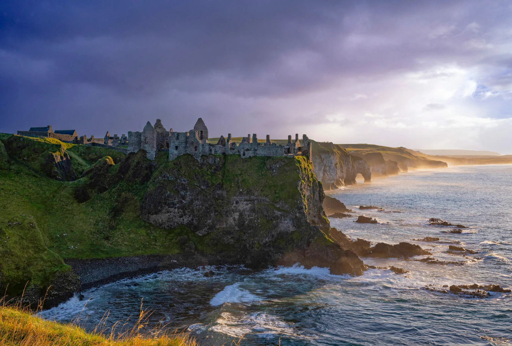
Dunluce Castle
Dunluce Castle, perched dramatically on a basalt outcrop along Northern Ireland's rugged Causeway Coast, is a testament to centuries of conflict, ambition, and legend. Its jagged cliffs plunge 100 fee...
Distance: 17.3 km

Bushmills Distillery
In the village of Bushmills on Northern Ireland's rugged north coast sits the Old Bushmills Distillery. It's famous for being the world's oldest licensed whiskey distillery, getting its permit from Ki...
Distance: 22.7 km