
Overview
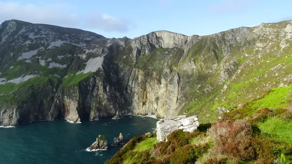
Bunglass Point is the main managed viewing platform for the Slieve League cliffs. It stands on the cliff complex in south-west County Donegal, where the plateau breaks off and drops sheer into the Atlantic. From behind the railings you look across the bay to the serrated skyline of cliff faces falling away to the water. They are cliffs worth the trip, among the highest sea cliffs in Ireland.

History and heritage
Two bits of Irish history sit along the approach and the point. On the way in, a squat stone signal tower stands at Carrigan Head, one of a chain built around 1804 to watch the Atlantic for a French invasion fleet during the Napoleonic Wars. Then, beside the upper car park, stone slabs still spell out ÉIRE on the ground, one of scores of markers laid along the coast during the Second World War to tell airmen they were over neutral territory. Worth a moment before you turn to the view.
Walking the cliffs
Bunglass Point is the managed viewpoint for the Slieve League cliffs, and it is a separate outing from the longer hill routes. There is no need to leave the platform to see the cliffs.
The viewpoint walk (easy to moderate)
Depending on the season and the access rules on the day, you may walk part of the way up from the car park or the visitor centre, with views opening onto the ocean along the way. It is well trodden and fine for casual walkers, but the ground is uneven and rocky in places. Wear sturdy footwear, because it gets slippery when wet. Follow the signed path and the directions of staff at the gate.
The Pilgrim’s Path (strenuous)
The Pilgrim’s Path is a different proposition, starting from a separate inland car park near Teelin. It climbs steeply through heather and loose stone towards the summit area. Beyond that, the ridge continuation towards Bunglass is the stretch known as One Man’s Pass, where the crest narrows hard between two drops. Strong winds or low cloud make it genuinely dangerous, so do not attempt it without experience of exposed ridge walking and a clear, calm forecast. There is a gate at the trailhead to keep livestock in, and this is sheep ground, so keep dogs on a short lead.
Getting there and parking
By car – Follow the signposted road towards Slieve League from the visitor centre. The visitor centre’s access guide lists free parking at the visitor centre, about 4 km from the cliffs, and paid parking at the ranger station, about 2 km away. The upper car park has its own access rules, which change with the season, so check them before deciding whether to drive, walk or ride. Follow signs and staff directions at the gate.
Parking charges – Charges apply at the ranger station and can vary by season, so bring a card or change and do not count on parking for nothing.
Shuttle bus – A seasonal shuttle runs from the visitor centre towards the viewpoint. Check the current timetable and fare with the visitor centre. It saves the narrow drive and the parking scramble on a busy day.
Public transport – Public transport options are limited in this part of Donegal. Check current Local Link and Bus Éireann timetables before relying on them, and expect to need a taxi for the last stretch.
Practical information
- Facilities: there are no toilets, cafés or visitor centres at Bunglass Point itself. Check what the Slieve League visitor centre currently offers, and bring water, snacks and a picnic if you plan to linger.
- Weather and safety: Atlantic weather turns fast. Fog, mist or strong wind can drop visibility to near zero and the cliff edge gets hard to see. Stay behind the safety railings, keep children close, keep well back from the drop, and check the forecast before you set out.
- Dogs: check the current rules with the visitor centre. Keep dogs on a short lead, for the drops and the livestock both.
- Accessibility: the operator describes the main viewpoint as wheelchair accessible. Contact the centre before travelling if you need accessible vehicle access or a drop-off. Other trails here are uneven and steep in sections.
Nearby
- Slieve League Visitor Centre – a few minutes’ drive away, with trail information, the seasonal shuttle and a place for a warm drink afterwards. Confirm current opening on the visitor centre site. (Slieve League)
- Assaranca Waterfall and Maghera Beach – if you continue towards Ardara, about 35–40 minutes’ drive north, Assaranca Waterfall is another stop. At Maghera Beach, enjoy the shore and view the caves from outside.
Come early. Morning gets you a parking space and catches the light on the cliff faces before the midday haze sets in.