
Overview
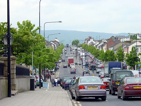
Cookstown’s long, broad main street runs through the centre of the County Tyrone town. It was laid out at that scale in the late 18th century by the Stewart family, with bulky loads of linen and livestock to move. It defines the place: one long line of Victorian shopfronts and churches in the middle of County Tyrone, between the foothills of the Sperrin Mountains and the Ballinderry River. Cookstown is the natural base for this stretch of Mid-Ulster.
Linen money
An English ecclesiastical lawyer, Dr Alan Cooke, leased the townlands here from the Archbishop of Armagh around 1620, and the town took his name. Livestock and linen built it: by the 19th century the weaving mills employed hundreds, and two railway termini connected Cookstown to Belfast before both closed in the mid-20th century. The construction left the place so strung-out and lean that it earned the nickname ‘Long Hungry Cookstown’. The linen trade went the way of all Irish linen in the last century, but the architecture it paid for survives, including Holy Trinity Church, the First Presbyterian Church and the old courthouse, and former civic buildings now house cultural venues. Walking the street feels more like a promenade than a shopping run, with the hills of the Sperrins in the distance.
Wellbrook Beetling Mill
Wellbrook Beetling Mill is a water-powered linen mill in a wooded glen on the Ballinderry, a short drive outside Cookstown. Beetling is the rhythmic hammering that gave linen its sheen, and the mill shows the original machinery at work when it is open. A woodland walk follows the old mill race. Check the National Trust’s calendar for public openings before travelling, as opening is conditional.
Lissan House
Lissan House sits in its valley on the Lissan Water on the edge of Cookstown, long the home of the Staples family. Its demesne takes in woodland, a walled garden and quiet walking trails. It is run by an independent trust, so check the trust’s visiting page for house tour arrangements and grounds access separately before you travel.
Stone circles and forts
- Beaghmore Stone Circles lie in open moorland at the edge of the Sperrins: Bronze Age stone circles, cairns and rows, dating to around 2900–2600 BC and only rediscovered in the 1940s when peat cutting exposed them. The Department for Communities lists free access, subject to works.
- Drum Manor Forest Park is an 18th-century demesne turned public forest park, another option for a marked walk. Check current parking arrangements before you go.
- Tullaghoge Fort, the ‘Mound of the Warriors’, is a circular earthwork on a drumlin south of town where the O’Neill chiefs of Tyrone were inaugurated, with wide views over the county.
The town today
The Burnavon Arts Centre on Burn Road opened in 2000 on the site of the demolished Town Hall, and has a programme of theatre, live music, film and community workshops. Check the council’s venue listing before making a trip for a performance. Cookstown also has a leisure centre, and shops, cafés and traditional pubs cover the practicalities.
Getting there and around
The A29 runs through town, south to Dungannon and on into the wider Mid-Ulster network. Check Translink before relying on buses for the town or outlying sites, and expect Wellbrook, Lissan and the Sperrin trails to need a car or taxi. Check current town-centre parking arrangements, including accessible spaces, before you travel.
If one trip out of town is all you have time for, make it Beaghmore: Bronze Age circles standing in open country, with the Sperrins behind them.