
Overview
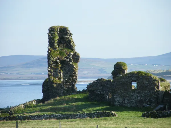
Doona Castle, also called Fahy Castle, was still said to be in “excellent preservation” in 1832, until a boy sent into the dark tower for turf during a christening left a burning ember behind. According to the story, the dry winter fuel caught, and by morning one whole side of the tower house had cracked and collapsed, reportedly burying several casks of smuggled spirits in the rubble. What’s left stands on a rise above the water in the townland of Fahy, near Ballycroy in north-west County Mayo: thick walls, a roofless shell, and a striking silhouette against the Atlantic sky.
A Tower House with a Turbulent Past
The castle’s dual name reflects the layered history of the region. “Fahy” comes from the Irish An Fhaiche, meaning “the green” or “the field”, while “Doona” derives from Dún, meaning “fort” or “stronghold”. Old maps recorded the site as Duna Castle, and the place-name survey of Erris includes early records of Doona. Irish tower houses of this kind typically had a vaulted ground-floor chamber for storage, narrow defensive slit windows, a spiral staircase embedded in the wall, and murder holes positioned above the entrance to drop projectiles on attackers.
Local tradition associates the castle with the legendary Pirate Queen, Grace O’Malley (Granuaile). According to local lore, she captured the castle from the MacMahon clan in retaliation for the killing of her lover, Hugh de Lacy. Another tradition links the castle to the aftermath of the wreck of the Spanish Armada ship La Rata Santa María Encoronada in Blacksod Bay in 1588, saying that Don Alonso de Leyva and his crew of survivors found refuge inside the castle walls before marching inland.
Following the Cromwellian campaigns of the 1650s, the castle is said to have been abandoned and to have fallen into decline. By the early 19th century, however, the main tower was reported to be in remarkably good condition. A November 1832 article in the Dublin Penny Journal noted the castle was in “excellent preservation” and its masonry “likely to have puzzled Father Time himself”. That praise was short-lived.
According to the journal, a local farmer named John Conway had piled a massive stack of winter turf against the courtyard wall. During a christening celebration, a young boy was sent into the dark, supposedly haunted tower to collect more fuel. Armed with a burning brand for courage, he gathered a basket of turf but accidentally left the ember behind. The dry fuel ignited, and the intense heat caused the ancient walls to crack and one entire side to collapse before morning. The fire reportedly buried several hidden casks of contraband spirits along with the stonework, marking the beginning of the castle’s decline into the roofless ruin you see today.
What to See & Do
Be realistic about what this is: a short roadside photo stop, not a destination to build a day around. The castle is not open for interior exploration, but its exterior remains highly evocative. See the tower from public ground, where you can photograph the remaining walls framing the surrounding pasture, the water and distant hills. The ground floor was built with a distinctive vaulted stone ceiling, and the broken shaft of the spiral staircase and the remnants of floor brackets give a sense of how the building’s levels were once connected.
The site works well as a quiet moment of reflection during a road trip. The castle sits on active private farmland, so the ruin itself should not be climbed or entered, and the fields around it are not a place to wander. They are often grazed by cattle and sheep, which adds to the pastoral atmosphere.
Getting There & Practical Tips
Doona Castle lies near Ballycroy, off the routes between Ballycroy and the Mullet Peninsula, and is best reached by car. Stay on public ground and leave field gates and road entrances clear. If there is nowhere safe to stop, continue on. The site is unmanaged and has no visitor facilities. Morning or late afternoon light tends to cast the most dramatic shadows across the stonework.
A few practical notes for visitors:
- Respect private property: The castle stands on working farmland. Stay on public ground and avoid walking through the fields.
- Footwear: Roadside verges can be uneven and grassy. Sturdy shoes are recommended if you step off the tarmac.
- Weather: North-west Mayo is exposed to Atlantic winds and sudden rain showers. Pack a waterproof jacket and consider wind protection for photography.
- Dogs: If you bring a dog, keep it on a lead near livestock and respect the landowner.
For a planned outing nearby, check Wild Nephin National Park’s notices for Ballycroy visitor centre and trail access.
Exploring the Surrounding Area
Doona Castle sits in a region rich with coastal scenery, ancient history, and outdoor recreation. If you have time to extend your visit, several notable attractions are within a short drive:
- Ballycroy (Wild Nephin) National Park – A vast wilderness of blanket bog, lakes, and mountain trails, with a visitor centre offering information on the local ecology (Ballycroy (Wild Nephin) National Park).
- Achill Island – Ireland’s largest island, known for its dramatic cliffs, pristine beaches, and the Achill Archaeological Field School (Achill Island).
- Westport – A busy coastal town, famous for its Georgian architecture, riverside gardens, and proximity to Croagh Patrick (Westport).
- Blacksod Bay – The historic coastline just south of Fahy, where the Spanish Armada ship La Rata wrecked in 1588. Survivors from the vessel temporarily sheltered in the area before moving inland.
The road network around Fahy is quiet and well-suited for cyclists and walkers. While there are no marked trails leading directly to the castle, the surrounding townlands are criss-crossed with minor roads that connect to broader rural routes. Keep an eye out for stone ringforts and old field walls that dot the landscape, remnants of centuries of farming and settlement in this remote corner of Mayo.
For precise navigation, the castle is at 54.0469°N, 9.9024°W. Photograph the walls from public ground, and picture the Armada survivors of local tradition sheltering inside them before they marched inland in 1588.