
Overview
Glennacally (Irish: Gleann na Caillí, ‘the hag’s valley’) is a large townland in County Mayo, a spread of winding streams and steep valley heads between Erriff Bridge and Glennacally Bridge on the N59. Its peaks form part of the Devilsmother, Maumtrasna and Partry Mountains. The ‘Hag’s Glen’ name comes from the Cailleach, the winter hag of Irish myth said to have shaped the land, and the valley wears its remoteness plainly: this is upland country, not a roadside stop.
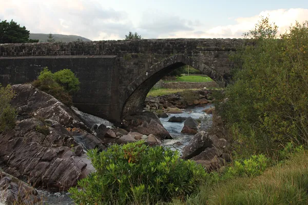
Glennacally Bridge
The National Inventory of Architectural Heritage records the stone bridge over the Glennacally River as a design by the civil engineer Alexander Nimmo. Its pointed arch and sandstone details are characteristic of its early nineteenth-century construction. It is plain, workaday masonry that still carries the N59, the main road linking Westport and Leenane.
Leave roadside gates and the bridge approaches clear. Informal approaches from the road can cross private land.
History & Background
The word cailleach historically referred to a nun, a veiled figure, or simply an old woman. Many Irish valleys adopted the ‘Hag’s’ prefix as a practical warning to keep children away from remote, uneven terrain. Throughout the 19th century, the townland appeared on maps as Glanacolla, Glen-na-Callie, and Glanicalle before standardising to Glennacally.
The surrounding peaks were once collectively known as the Formnamore Mountains (from formna mór, ‘great shoulder’). That collective name faded, and the summits are now named individually: Benwee (Binn Bhuí), the Maumtrasna plateau with its trigonometric pillar, Glenagleragh Hill, Gowlan, Binn Garbh, and the distinctive horseshoe ridge of the Devilsmother.
The hills above the valley
On clear days the ridges of the Devilsmother open up sweeping views of the Maumtrasna massif, the deep hollows of Luga Kippen and Luga Gowlan, and distant glimpses of Killary Harbour. The Devilsmother’s horseshoe shape is a favourite subject for landscape photographers, particularly in the low light of autumn mornings.
Walking in the area
The surrounding mountain ground is exposed, and informal approaches can cross private land. For a walk, choose a published route with a designated start and check current access before setting out. There is no car park at the bridge, and gates and roadside verges should be left clear.
Mayo mountain ground is genuinely treacherous when wet, and slopes turn dangerous on the steeper descents. Carry an Ordnance Survey Ireland map, a compass and a charged GPS; reception is patchy in the hills. There are no facilities, bins or shops in the hills, so bring your own water, food, a first-aid kit and spare layers, and leave your route plan with someone before you set off. Keep dogs on a short lead around livestock, and check for grazing notices before visiting.
Nearby Attractions & Day Trips
- Aasleagh Falls – A short drive north-west leads to a dramatic waterfall and a popular picnic spot with easy access from the roadside.
- Ballycroy National Park – The visitor centre offers guided walks, dark-sky programming, and exhibits on peatland restoration and upland ecology.
- Westport & Leenane – Both towns provide cafés, fuel, accommodation, and access to the Great Western Greenway for a low-impact day.
Start any hill day early to avoid afternoon cloud build-up over the Maumtrasna ridge.