
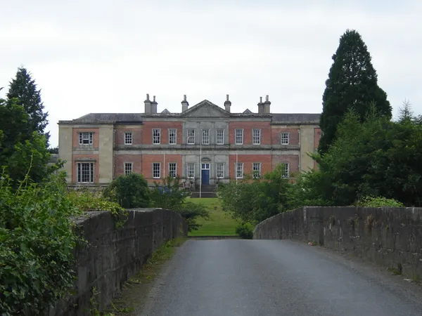
Ballyhaise was laid out as a planned estate village around a market place, which makes it worth a look in a country where most villages simply grew along a road. The streets radiate from the centre out to a Fair Green, the whole scheme the work of one improving landlord in the early 1700s. The National Inventory of Architectural Heritage describes Brockhill Newburgh’s eighteenth-century plan as a decagon, with part of the original building line still visible. At the centre of it all is Ballyhaise House, built around 1730, with an oval room that architectural historians have long noted.
One honest caveat before you set out: the house is now the Teagasc agricultural college and a working campus, not a visitor attraction, so you are admiring the architecture from public areas and walking the village rather than touring grand interiors. Come for the layout, the house seen from the public road, and the river.
The planned village
The man behind it was Colonel Brockhill Newburgh, who in the first decades of the 18th century set about turning his estate into a model of orderly town planning. He laid out the market place, the radial roads running off it, and a Fair Green at the end of Fair Hill. A visiting clergyman in 1739 said Ballyhaise was ‘made to last forever’, and the bones of Newburgh’s plan are still legible on the ground today.
The Market House sits at the centre. Newburgh’s original, an arched brick building, went up around 1730 but had collapsed by 1736; the present random-rubble structure was rebuilt in 1837 and keeps something of the old form, with five large granite arches at ground level. It is a working building rather than a polished monument, with modern uPVC windows that do it no favours, but it anchors the square.
Ballyhaise House
Built around 1730 for Colonel Newburgh, the house is brick-faced with ashlar dressings, two storeys over a basement and seven bays wide, with a pedimented centre carried on Ionic pilasters. Its real distinction is inside: the oval room. One quirk the architecture books note is that all the floors are vaulted in stone, not just the basement, a deliberate fire precaution that was unusual and expensive.
The house has been an agricultural college since the early twentieth century and is now a Teagasc college. It is a working campus, so the interiors are not open to casual callers. Check directly with the college about any organised access, and keep to public areas for a village walk.
The bridge and the river
Ballyhaise Bridge carries the road over the River Annalee on the edge of the village. It is about three centuries old, built in Newburgh’s improving era, its limestone arches lined up with the axis of the village so the square, the bridge and the house all read as one design.
Opposite the college, a park runs along the bank of the Annalee, an easy, flat place for a short walk by the water. Keep clear of the riverbank when the water is high. The river is also a game-angling water, but fishing rules and permits change, so check Inland Fisheries Ireland and confirm access and permits for the reach you intend to fish. There is further fishing on the Annalee at Deredis, near Butlersbridge just up the road.
Getting there and around
Ballyhaise is about 7km north-east of Cavan town, and roughly 11km from the Fermanagh border by the N54. Use designated parking in the village. Local Link buses have served the village, though as with most rural services you should check the current timetable before relying on one. For a fuller choice of food and beds, Cavan town is ten minutes down the road.