
Overview
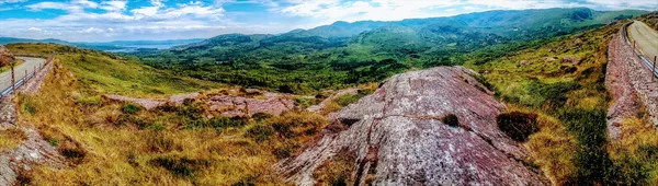
These are the “Cork and Kerry mountains” of the song Whiskey in the Jar: a low sandstone range, An Cheacha in Irish, running down the middle of the Beara Peninsula in south-west County Cork and carrying the Cork–Kerry border along its crest. Hungry Hill reaches 685m; Knocknagree, Sugarloaf Mountain and Baurearagh Mountain fill out the ridgeline.
Most people experience the Cahas from a car, over one of the two passes, and that’s no bad way to do it. The range is also a Special Area of Conservation: the Caha Mountains SAC protects mountain habitats including heath, bog and rocky slopes.
History & Landscape
Long before modern roads carved through the rock, the Caha range served as a natural boundary and a cultural landmark for local communities. The mountains are primarily composed of Devonian sandstone, formed from ancient riverbeds that were later uplifted and sculpted by glacial action during the last Ice Age. This hard, erosion-resistant rock creates the dramatic crags and cliffs that dominate the higher elevations.
People have crossed and quarried these hills for a long time. A hoard of copper axes, a halberd and a dagger from the early Copper Age, around 2000–1800 BC, was dug up at Killaha, and during road-widening at Bonane workers broke through into a souterrain, an underground passage roughly a thousand years old.
The bigger marks on the land are the two passes. In the mid-19th century two tunnels were blasted and then hand-hewn through the rock to create the Caha Pass, the link between Kenmare in Kerry and Glengarriff in Cork; it was paved in the early 1900s by the cyclist and motoring pioneer Richard Mecredy. The Healy Pass began as a famine-relief road of 1847, the bridleway the Irish call Bealach Scairt, and was widened in the 1930s and renamed after Tim Michael Healy, the first Governor-General of the Irish Free State.
The two drives
The Caha Pass and the Healy Pass are separate crossings. Between Glengarriff and Kenmare, the N71 passes through the Caha Pass tunnels. The Healy Pass is a different crossing, between Adrigole on the Cork side and Lauragh on the Kerry side.
The Healy Pass is the more dramatic drive, with a stack of tight hairpins and a view at the top over the bogs and out towards Bantry Bay. The catch is the same as the appeal. It is narrow and exposed, the bends are blind, and hill fog can drop without warning, so a nervous driver will find it hard work and is better off skipping it in bad weather.
The Caha Pass on the N71 is the gentler choice and a fine drive in its own right, weaving through green slopes and a boggy plateau before threading two tunnels. The low tunnels keep the tour buses out, which keeps the road quiet.
Both passes have narrow bends and exposed stretches. Check road conditions and stop only at a safe designated space. Never stop in the tunnels or on blind bends, and give way early at blind bends rather than meeting someone halfway round one.
Walking & Wildlife
While the passes cater to motorists, the higher ridges and plateaux offer opportunities for walking and wildlife observation, and the SAC designation protects a range of species.
Flora & Fauna
The alpine heath and dry grasslands support rare botanical finds, including alpine sandwort (Minuartia recurva), heath pearlwort (Sagina subulata), and the Killarney fern (Vandenboschia speciosa). The wetter, boggy areas are home to the elusive Kerry slug, a species of conservation interest. Peregrine falcons breed on the higher cliffs and ring ouzels pass through during migration. Otters, badgers, and brown trout can also be spotted in the streams and valleys that cut through the range. Keep to established paths and leave plants and stones in place.
Walking Routes
For a signed outing, choose a section of the Beara Way, the long-distance trail around the peninsula, and plan a return. Ridge and summit routes involve open ground and navigation. Check permissions, weather and your route before leaving a public road or marked trail. Terrain can be boggy and exposed, so waterproof footwear and a weather-proof jacket are essential. In winter, snow and ice can make the higher sections hazardous, so check conditions before setting out.
Nearby Bases & Attractions
Most visitors use the coastal villages at the foot of the mountains as their base. Glengarriff, sheltered by the range’s southern slopes, offers accommodation and cafes. Castletownbere is a fishing port on the peninsula. The village of Adrigole is a starting point for exploring the southern slopes, and Allihies is home to the historic Allihies Copper Mines.
Practical Information
- Parking: use a designated stopping place and keep bends and tunnels clear. Do not park on the carriageway or block the narrow roads.
- Transport: public transport options are limited in this rural area. Check current timetables before travelling.
- Conservation: as a Special Area of Conservation, the mountains are ecologically sensitive. Stay on established paths, take all litter home, and avoid disturbing nesting birds or protected ground flora.
Time the drive for late afternoon, when the light comes in low off the Atlantic, and pull into a designated space rather than stopping on the road itself; the best of the Cahas is in the stopping, not the driving through.