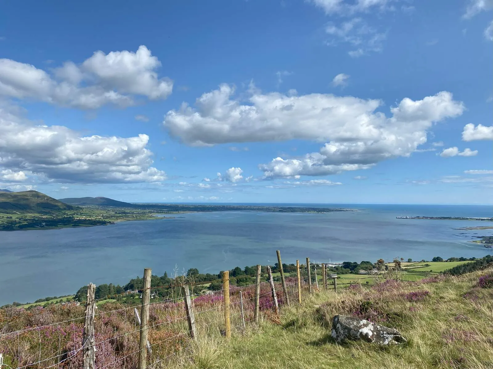
Discover the Cooley Peninsula in County Louth, where the rugged Cooley Mountains rise against the skyline. The highest point is Slieve Foy, standing proud at 589 meters (1,932 feet). Locals know it as Sliabh Feá, meaning "mountain of the woods," and from its summit, you get incredible views over Carlingford Lough towards the Mourne Mountains. On a really clear day, you might even spot the Isle of Man. But Slieve Foy isn't just about the views; it's wrapped up in ancient Irish myths. Stories from the Tain Bó Cúailnge, Ireland's great cattle-raid epic, mention Queen Medb's armies carving the Barnavave Gap through the mountainside. And don't forget the leprechauns! In 2009, Slieve Foy was actually given EU protection as a habitat for plants, animals, and the "little people."
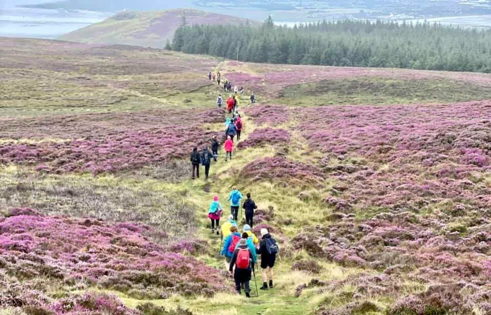
Fancy a hike? The Slieve Foye Loop is a 9-kilometer trail marked with blue arrows. Be prepared for steep climbs and uneven ground, but the payoff is huge – stunning panoramas from rocky spots like Eagles Rock and Ravens Rock. The path takes you through pine forests and across open ridges, climbing 270 meters to the summit, where it's often windy but the 360-degree views are worth it. The trail starts conveniently near Carlingford town, so you can grab supplies before you head off. A heads-up: some parts of the trail can be overgrown or tricky to follow, so bringing a map is a good idea.
There's more to explore in the Cooleys than just the main peak. The Tain Way is a 40-kilometer loop following the legendary path of Cú Chulainn. If you visit in autumn, the Wee Binnians Walking Festival opens up less-trodden paths. Winter hikes offer a stark, quiet beauty, while spring and summer are perfect for longer visits when the landscape is in bloom. The heart of the area is Carlingford itself – a gorgeous medieval town with cobbled streets, cozy pubs, and craft shops. Whether you're climbing Slieve Foy or just soaking up the legends, the Cooley Mountains feel like a place where myths and reality meet.
Getting There
By Car
The region is easily accessible by car: - From Dublin: Take the M1 north toward Dundalk, then follow the N13 or R173 signs to Carlingford. The journey takes approximately 1-1.5 hours, covering around 90km. - From Belfast: Drive south on the M1 toward Dublin, then take the A2/M1 to Dundalk before following signs to Carlingford. This route takes roughly 1.5-2 hours, covering about 120km. - From Dundalk: The drive to Carlingford takes around 30 minutes via the R173.
By Public Transport
- Bus: The Bus Éireann 161 service connects Dundalk (County Louth) to Newry (County Down), passing through Carlingford, Greenore, and Omeath. Services are limited, so check schedules in advance. The Dundalk Bus Station is the primary departure point.
- Ferry: The Carlingford Ferry operates between Greenore (Republic of Ireland) and Greencastle (Northern Ireland), offering a 15-minute crossing across Carlingford Lough. This is ideal for visitors arriving from Northern Ireland.
Local Access
- Starting Point: The Slieve Foye Loop and other trails begin in Carlingford town. Key trailheads are near the Carlingford Tourist Information Office, where walkers can follow waymarked paths (yellow and pink arrows) leading to the Táin Way. The Táin Way, a 40km national trail, provides clear signage from the town center.
- Walking/Cycling: The Carlingford Greenway, a 7km path linking Carlingford to Omeath, is perfect for cyclists or walkers exploring the peninsula. It connects to trail networks near Slieve Foye.
Alternative Routes
- From Omeath: The Táin Way can also be accessed from Omeath, with connections to the Slieve Foye Loop.
- Ferry Option: Arriving by ferry to Greenore allows visitors to combine the crossing with a drive or walk into Carlingford.
Once in Carlingford, the hike to Slieve Foye's summit (589m) begins near the town's center, following well-marked trails that ascend through grassy slopes and pass historical landmarks like the Church of the Holy Trinity. Allow 2.5-3 hours for the round-trip hike, which covers approximately 9km.
Parking
Parking Options:
Visitors to the Cooley Mountains and Slieve Foy will find parking primarily in the town of Carlingford. The main Carlingford Car Park is centrally located and offers a reliable spot, while additional options include the Tourist Office car park, the Slievefoy Forest Car Park, and smaller lots near Carlingford Lough (on the left as you enter town). Street parking is available along the waterfront and town roads but can fill quickly on weekends or during peak summer months.
Fees & Accessibility:
Most parking in Carlingford is free, including roadside spots and the town car parks. However, some designated car parks (like those managed by forest parks) may charge a fee-though specific details are not widely documented. Always check signage upon arrival. Disabled parking is available in town facilities, though availability varies; arrive early to secure a spot.
Peak Time Tips:
During busy periods (June to August), parking fills rapidly. For guaranteed spaces, consider:
- Arriving early in the morning.
- Using overflow lots like Two Mile River Car Park or Annaloughan Loop Walk Car Park, which are a short drive from the town center.
- Parking at Carlingford Marina for camper vans, which also offers overnight stays.
Distance to Trailheads:
The majority of parking areas in Carlingford are within a 10-15 minute walk of the Slieve Foye Loop trailhead. The Slievefoy Forest Car Park and Annaloughan Loop Walk Car Park are slightly farther out (1-2 miles) but provide direct access to forest trails and mountain paths, reducing walking time to higher elevation areas.
Important Notes:
- No dedicated parking exists at the summit of Slieve Foy; all visitors must park in town or at designated lots before hiking.
- Avoid leaving valuables visible in parked vehicles, especially in busy areas.
Pricing
Admission Fees
- Free Access: The trails in the Cooley Mountains and Slieve Foy are open to the public at no charge. Parking at trailheads is also free.
Guided Tours & Activities
- Standard Tours: Guided hikes and tours range from €38 to €100 per person, depending on the provider and duration.
Nearby Attractions
Cooley Peninsula Scenic Route
The Cooley Peninsula Scenic Route winds through a landscape steeped in myth, history, and natural beauty, offering a journey into the heart of Ireland's ancient and enduring heritage. Located in Count...
Distance: 4.3 km
Cranfield Beach
Cranfield Beach, located at the southernmost tip of Northern Ireland in County Down, sits at the mouth of Carlingford Lough, offering a unique intersection of coastal beauty and historical intrigue. T...
Distance: 7.4 km
Castle Roche
Castle Roche, an imposing 13th-century Anglo-Norman fortress, rises dramatically from a rocky outcrop in County Louth, marking the contested boundary between the Gaelic province of Ulster and the Engl...
Distance: 19.8 km